
An Overview of GPS and How it Works

27.11.2010
How GPS Works
I have tried to keep this a simple as possible but it is a very complex subject.
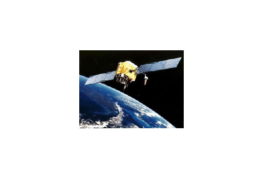
The GPS satellites are in orbit around 12,500 miles up and travelling at about 2000 mph.
Their orbits are inclined to the equator by 55° and their orbital period is half a sidereal day, 11 hours and 58 minutes.
How we can get such accurate positional information is I think quite amazing, bearing in mind that we must not only know their individual positions at a specific time but also measure the time it takes for radio waves to get from each of them to our receiving antenna. Radio waves travelling at approximately 300,000,000 metres per second effectively means that if we want our position to within say 5 metres, we must measure time to at least an accuracy of 1/100 of a millionth of a second = 0.01 microseconds – something we cannot perhaps appreciate clearly.
GPS is based on accurately measuring the transit time of signals transmitted from each satellite to the user’s Receiver. Each satellite transmits a number of accurately timed signals as well as a navigation message which includes information used to determine very accurately the time these signals were transmitted, satellite clock corrections and, where the satellite was located at that time (satellite orbit or ephemeris data). The Receiver measures the time-of-arrival (TOA) of each signal using the receiver's own internal clock (which will be in error – see below) and then determines the range of each satellite, based on the speed of light. Then by making such measurements from at least 3 satellites and knowing we are on the surface of the earth, it is actually simple maths, using three simultaneous equations, to eliminate our clock error. Knowing the range to a number of satellites and the satellite positions permits determination of the user’s position.
In practice, marine navigation receivers employ crystal oscillator clocks which are accurate enough for the short time it takes to get a fix. The difference in the time known to the boat's receiver can be considered constant but does of course introduce errors into the TOA measurements. This timing error translates into a range errors common to all the GPS ranges measured at a particular time. The measured ranges containing this common clock error are called “pseudo-ranges”. If true satellite ranges could be measured directly, just two satellites would be required to determine a vessel’s position assuming the boat is on the earth's surface. When a user’s elevation is known (as it is on the ocean), two ranges to two known satellite positions are sufficient to determine latitude and longitude.
However, when pseudo-ranges are measured, a third satellite must be used to determine, and thereby eliminate, the common clock error. Mathematically this is a case of using three simultaneous equations (one for each pseudo-range) to solve for three unknowns (clock error, latitude, and longitude).
GPS SIGNALS
Each GPS satellite transmits a number of signals that can be used for position measurements. Two 'low' microwave carrier radio frequencies (around 1600 MHz or ten times your VHF radio channels), Li and L2, are modulated by accurately timed pseudo-random binary sequences or codes. One frequency carries both the C/A (Coarse/Acquisition) and P (Precision) -codes while the other frequency carries only the P code. Each of the radio signals also carries a 50 bps (Bits per Second) Navigation Message which includes satellite clock correction data, ephemeris data for each satellite, and almanac data for the entire constellation. Commercial marine navigation receivers operate primarily by detecting and tracking the C/A code.
Receivers operate by generating an internal duplicate of the C/A code sequence (known as a Gold Code that takes just one millisecond to be transmitted by each satellite and consisting of 1023 bits – 1s and 0s being binary code) and the computer within the boat's receiver shifts its own generated code in time until it correlates with the received C/A code. The C/A code being relatively short requires therefore a bit-by-bit search for correlation which can be accomplished fairly quickly. This correlation process can resolve the time of arrival of the received signal to a fraction of the C/A code’s 1 microsecond bit period.
GPS receivers make certain assumptions for the propagation time of signals through the earth’s ionosphere. These assumptions are typically in error by 5 to 8 metres. This error can be virtually eliminated if measurements are made on both the received frequencies simultaneously. However, as this P Code (Precision) is not available for civilian use, today's receivers use other 'cunning plans' to eliminate most of these radio propagation errors.
Boat owners will not in most cases be aware that while the time it takes radio waves to travel through space is for many purposed assumed to be constant, when one needs the sort of timing accuracies (see above) that are needed for GPS, the receiver's computer software must take into account things like refraction when the radio waves are 'bent' while passing through the atmosphere. Also other very obscure things upset the timing, like the waves having to pass through the Appleton layer and the fact that clocks travelling through space experience errors as defined by Einstein in his laws of relativity – something I find very difficult to understand when talking about time and what we mean by 'time'.
DILUTION OF PRECISION
As in all radio navigation systems, the accuracy is affected by the geometry of the situation. Probably the most familiar examples of this today is the practice of avoiding 'small crossing angles' in lines of position, whether these lines are electronically generated or using a conventional sextant or even a handbearing compass and plotting the traditional way on our paper charts. GPS employs moving transmitters (satellites) and therefore the geometry or crossing angles are constantly changing. In 2-dimensional GPS navigation, the lines of position are moving circles on the earth’s surface that are, at all points, equidistant from each satellite. The effects of geometry on accuracy can be summarized in a single number, called the Horizontal Dilution of Precision (HDOP). The accuracy obtainable from a particular set of satellites is equal to the error in the pseudo-range measurements multiplied by the HDOP. In order to avoid extra-ordinary errors due to short periods of very poor geometry, GPS Receivers usually employ an algorithm which selects satellites based on the lowest HDOP. These Receivers will either stop processing positions or flash a warning when the HDOP exceeds some preset value.
STANDARD AND PRECISE POSITIONING SERVICES (SPS AND PPS)
The US Department of Defense adopted a policy that limits the performance of GPS available to all but DoD authorised users.
Since a prior knowledge of the pseudo-random code sequence is essential for creating a false or spoofing GPS signal, DoD intended to change the published P-code to a Y-code that would not be published but could be determined only by access to encrypted information in the satellite navigation message. This is an anti-spoofing technique denying to the civil community the inherently higher resolution of the P-code and the ability to measure and correct for all ionospheric errors. A second cryptographic technique, termed Selective Availability (S/A) did early on when GPS became available, degrade the C/A code accuracy available to civil users by 'wobbling' the time on the satellites and also reducing the accuracy of the orbital data. These errors were inserted into the satellite ephemeris data such that the position accuracy available to civil receivers was degraded to around 100 metres (2 drms). Quite some years ago now, the US Government removed these deliberate errors so that now even inexpensive GPS receivers can provide accuracies to the order of 5 metres or better.
Like all electronic position determining kit, once you have the vessel's position known, the computing necessary to provide things like the distance and bearing to waypoints (either rhumb line or great circle) or setting up a route containing several waypoints is easy but users must remember that if the vessel's position is wrong, then all navigational info will also be wrong. This was something I had to deal with regularly with yachtsmen when the first, previous satnav system (and the older Decca hyberbolic radio system) came into use by yachtsmen in the 1980s.
Just as a matter of interest, special GPS receivers used for survey work can, for some years, obtain accuracies down to a few millimetres by not only doing the normal calculations but also measuring the electronic phase of the radio signals as they are received. Phase measurements mean that with the signals having a frequency of about 1600 MHz, one can track the timing within each cycle of the signal. Amazing how today's technologies have changed!
All images are copyright RIB & HSC 2024 unless otherwise stated.
This does not exclude the owner's assertion of copyright over the material.
05.04.2024
Hydro Motion - H2 from NL to England in 2024
The TU Delft Hydro Motion Team wants to cross to…
05.01.2024
The Challenges of Unpredictable Marine Energy
From military to superyacht, it is clear there is an urgent…
Speed@Seawork 2024
Dates:
10th June 2024
Location:
Cowes, Isle Of Wight,
Foiling and Flying RIBs
Foiling powerboat designed to meet military needs - fast, stable, silent, fuel-saving. Collaboration by SEAir Foiling Systems and Sillinger RIBs.…